Mount's Bay  50BC
treeve

Mount's Bay 50BC

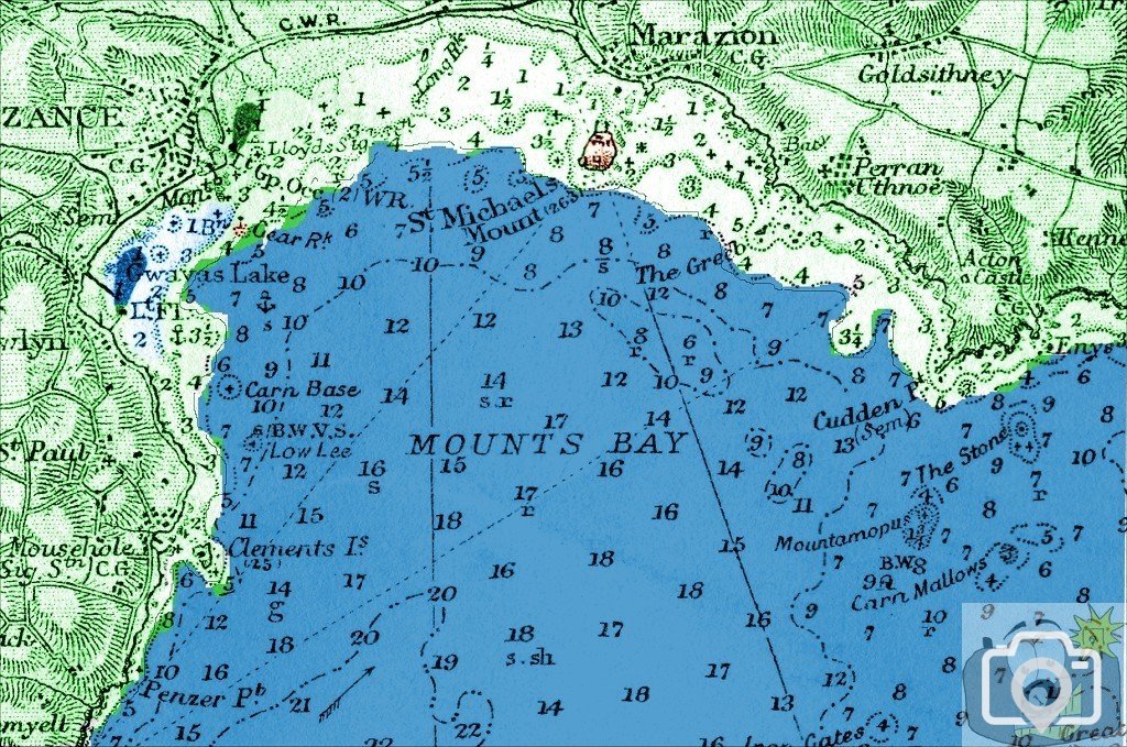
It is 50BC, the sea is at a different level. It is 14,000 years since the last Ice Age, seas have been rising, due to ice melt into the sea, and Britain's isostatic rebound. There is to be constant inundation and constant erosion of the coast. There are enough written records and events that have been ignored from many texts. As time progresses the sea encroaches the shore, as it will continue to do for some time yet, another thousand years, who can be certain? This is a map based on the 1848 Admiralty map. By simple calculations based on facts it can be determined that there is 21 feet of water lower than is now. Taking this back to the 1850 soundings and adjusting the levels, adding 6 feet of soil to the rock, by following the 4 fathom depth, this is the coastline in 50BC.
In brown are Gear and The Mount. A suggested area where the fresh water Gwavas Lake was.
I wonder on what or who the locals at the time blamed global warming and encroaching seas post 50 BC?
 
In the 19th century, it was just as much a mystery, it generated a massive interest in the scholarly with weather and the phenomena. Crops were tells, cloud colours were tells, a massive interest in seas, everything except the truth of the matter - much as today. I have placed much on Penzance 1675. I will also plot out a front for 1014, when the breach occurred. Having done this one, I will be more accurate for others. In fact I intend to do this one again and be more specific.
 
I should add that it was Polwhele who had the first notion it could be the ground was 'sinking'. So that is half the story. The rest was and is due to ice melt of the residual kind. Dr Borlase was aware of the perturbations from earthquakes, as it was then considered possible for it to be from submarine earthquakes. Before then of course, there was little knowledge at all, and it was mainly due to some punishment from 'Above'. It was from Dr Borlase's study of The Isles of Scilly that some inkling that something major was afoot. Polwhele asks about Lyonesse, in this context. I doubt there was a continuous land bridge in 'memory' but certainly a large portion of those intermediate rocks bore soil above the waves.
 
Taking a look at St Michael's Mount if a southern harbour were to have been constructed and the area was accessible by Phoenicians ships, or traders from Armorel, or even Roman or Greeks, in no way could it have been seen as an island. Least of all having a causeway or access that was covered in sea as Diodorus describes.
 
I wrote a comment on your fascinating map - awe-inspiring! - and can't have posted it last night! Oh well! This subject requires a book to itself. Your adaptation of this map describes a compelling likelihood. I am only too ready to accept your judgement, Treeve. I'd be interested to see if it would stand up to the scrutiny and expertise of qualified scientists in the geological, geographical and historical field given the evidence that you have researched. There is bound to be a lot of conjecture involved when one is dealing with such a bygone era in that it is hard to prove and disprove. I can only praise you for your perseverance and hard work, without wanting to sound too sycophantic.
 
Thank you, I have been working on information gathering for quite some time. Incidentally, the FACTS as far as the ice melt scenario, then and now are laid out by someone who knows - Wm. Robert Johnston Ph.D. (Physics), M.S. (Physics), B.A. (Astronomy) (as well as the IPCC - Intergovernmental Panel on Climate Change); the FACTS as far isostatic rebound are concerned is widely accepted standard science. By applying contemporary narrative to the map coupled with the basic maths, it tallies. The amount of soil is pure conjecture, but the degree and composition coupled with the effects of weather wil determine the precise amounts of erosion at any one stage or position. The position of 'Gwavas Lake' tallies with the river Lariggan AND Newlyn Coombe, which explains a lot. Given the possible coastline, it is quite possible for there to have been hamlets built closer to the shore, swamped by the incoming sea. So Leland could well be right. It has been easy for past observers to dismiss previous writers' accounts on the basis of their own science. As far as I am concerned not a great deal has changed in human observation, just in the way it is wrapped.
 
A point I have omitted - Gear Rock, origin of Neolithic axes; reported by others, but confirmed by Cornish Archaeology c1962. I am trying to get details, beyond those by Dr Borlase. The scene of axe makers on the rocky shore can now be seen.
 

Media information

Album
Smoke on the Water
Added by
treeve
Date added
View count
1,850
Comment count
8
Rating
0.00 star(s) 0 ratings

Share this media

Top Bottom